
")
")
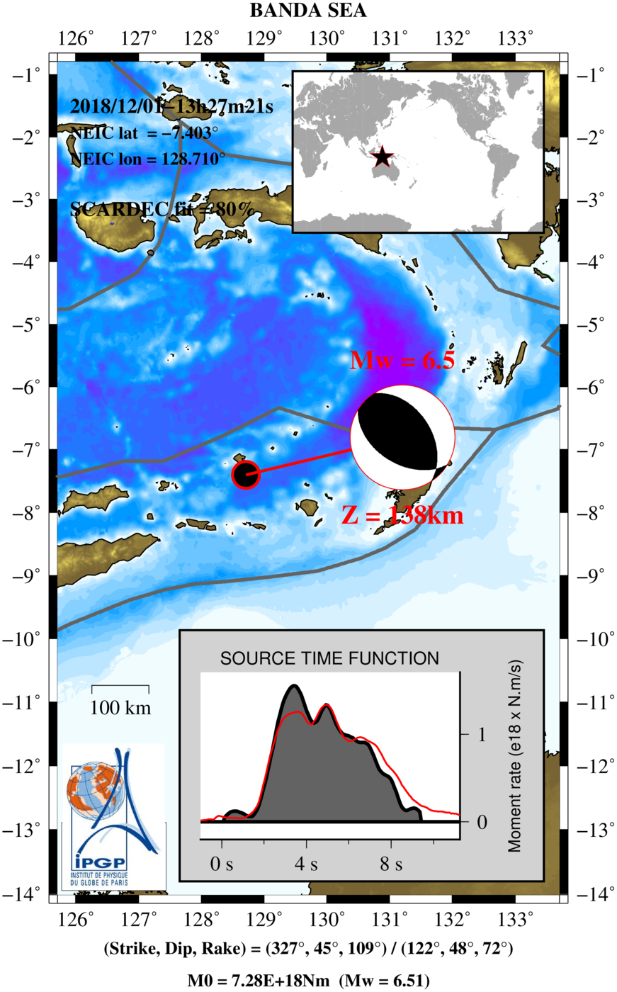
 BANDA SEA 2018/12/01 13:27:21 UTC, Mw=6.5
SCARDEC method: Analysis of the earthquake sourceSCARDEC method uses the teleseismic body waves to retrieve the depth, focal mechanism, moment magnitude and source time function of earthquakes with magnitudes larger than 5.5-6. Details of the methodology are described in Vallée et al. [2011] and an application to all earthquakes with magnitude larger than 6 in the period 1992-2011 can be found in Vallée [2013]. The consolidated SCARDEC catalog, with full access to earthquake parameters and source time functions, can be found here. See more information (about the data, the procedure, the reasons that could prevent from providing the earthquake information, the source time function determination...) in the "detailed notes"  . . If using some of the SCARDEC results, please refer to: (1) Vallée, M., J. Charléty, A.M.G. Ferreira, B. Delouis, and J. Vergoz, SCARDEC : a new technique for the rapid determination of seismic moment magnitude, focal mechanism and source time functions for large earthquakes using body wave deconvolution, Geophys. J. Int., 184, 338-358, 2011. The method is running and maintained at IPGP laboratory. Apart from IPGP, past and present support to the development of the method are/were provided by the following institutes/projects :
We are grateful to the organisms providing, managing or federating data:
is used for drawing some maps of the webpage. |
|||
 Automatic determination of source parameters using the SCARDEC method Automatic determination of source parameters using the SCARDEC method |
|||
|

|
||
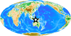 Interactive map of the regional seismicity of the last ten years (Magnitude > 5; Source USGS)
 | 9 |
| 8 |
| 7 |
| 6 |
| 5 |
 : GEOSCOPE stations - The information about the plate tectonics are provided by USGS and Bird (2003)
Interactive map of the foreshocks and aftershocks
: GEOSCOPE stations - The information about the plate tectonics are provided by USGS and Bird (2003)
Interactive map of the foreshocks and aftershocks(2 weeks before and 2 weeks after the earthquake - Source USGS)
| Foreshock | Aftershock | Mag. |
|  | 7 |
| | 6 |
| | 5 |
| | 4 |
| | 3 |
Earthquake data of the GEOSCOPE stations
 Download the SEED volume (20000 seconds of data)
Metadata and time series
List of miniSEED segments
Theorical arrival times at GEOSCOPE stations
 Display arrival times at available GEOSCOPE stations
Earthquake records
| Code | Location | Lat. | Lon. | Elev. | Description | Records |
|---|---|---|---|---|---|---|
| AIS | Nouvelle-Amsterdam - TAAF, France | -37.796° | 77.569° | 0.036 km | Show station description | Show records |
| ATD | Arta Cave - Arta, Republic of Djibouti | 11.531° | 42.847° | 0.61 km | Show station description | Show records |
| CAN | Canberra, Australia | -35.319° | 148.996° | 0.7 km | Show station description | Show records |
| CCD | Concordia Base, Dome C, Antartica | -75.107° | 123.305° | 3.24 km | Show station description | Show records |
| CLF | Chambon la Foret Observatory, France | 48.026° | 2.26° | 0.145 km | Show station description | Show records |
| COYC | Coyhaique, Chile | -45.573° | -72.081° | 0.235 km | Show station description | Show records |
| CRZF | Port Alfred - Ile de la Possession - Crozet Islands, France | -46.431° | 51.855° | 0.14 km | Show station description | Show records |
| DRV | Dumont d'Urville - Terre Adelie, Antarctica | -66.665° | 140.002° | 0.04 km | Show station description | Show records |
| DZM | Dzumac - New Caledonia, France | -22.072° | 166.444° | 0.878 km | Show station description | Show records |
| ECH | Echery - Sainte Marie aux Mines, France | 48.216° | 7.159° | 0.58 km | Show station description | Show records |
| FDF | Fort de France - Martinique island, France | 14.735° | -61.146° | 0.467 km | Show station description | Show records |
| FOMA | Nahampoana Reserve - Fort Dauphin, Madagascar | -24.976° | 46.979° | 0.028 km | Show station description | Show records |
| FUTU | Maopo'opo, Futuna | -14.308° | -178.121° | 0.097 km | Show station description | Show records |
| HDC | Heredia, Costa Rica | 10.002° | -84.111° | 1.186 km | Show station description | Show records |
| INU | Inuyama, Japan | 35.35° | 137.029° | 0.132 km | Show station description | Show records |
| IVI | Ivittuut, Greenland | 61.206° | -48.171° | 0.015 km | Show station description | Show records |
| KIP | Kipapa, Hawaii, USA | 21.42° | -158.011° | 0.11 km | Show station description | Show records |
| MPG | Montagne des Peres - French Guiana, France | 5.11° | -52.644° | 0.147 km | Show station description | Show records |
| NOUC | Port Laguerre - New Caledonia, France | -22.099° | 166.307° | 0.137 km | Show station description | Show records |
| PAF | Port aux Francais - Kerguelen - TAAF, France | -49.351° | 70.211° | 0.017 km | Show station description | Show records |
| PEL | Peldehue, Chile | -33.144° | -70.675° | 0.7 km | Show station description | Show records |
| PPTF | Pamatai - Papeete - Tahiti island - French Polynesia, France | -17.59° | -149.565° | 0.705 km | Show station description | Show records |
| RER | Riviere de l'Est - Sainte Rose - La Reunion island, France | -21.171° | 55.74° | 0.834 km | Show station description | Show records |
| ROCAM | Leguat Reserve, Rodrigues Island, Republic of Mauritius | -19.756° | 63.37° | 0.052 km | Show station description | Show records |
| SPB | Sao Paulo, Brazil | -23.593° | -47.427° | 0.647 km | Show station description | Show records |
| SSB | Tunnel de Badole - Saint Sauveur en Rue, France | 45.279° | 4.542° | 0.7 km | Show station description | Show records |
| TAM | Tamanrasset, Algeria | 22.791° | 5.528° | 1.41 km | Show station description | Show records |
| TAOE | Taiohae - Marquesas islands, France | -8.855° | -140.148° | 0.8 km | Show station description | Show records |
| TRIS | Tristan da Cunha | -37.068° | -12.315° | 0.06 km | Show station description | Show records |
| UNM | Unam - Mexico, Mexico | 19.33° | -99.178° | 2.28 km | Show station description | Show records |
| WUS | Wushi - Xinjiang Uygur, China | 41.201° | 79.216° | 1.468 km | Show station description | Show records |
Records from LHZ channel of GEOSCOPE stations
Download graphic file in PDF format

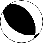
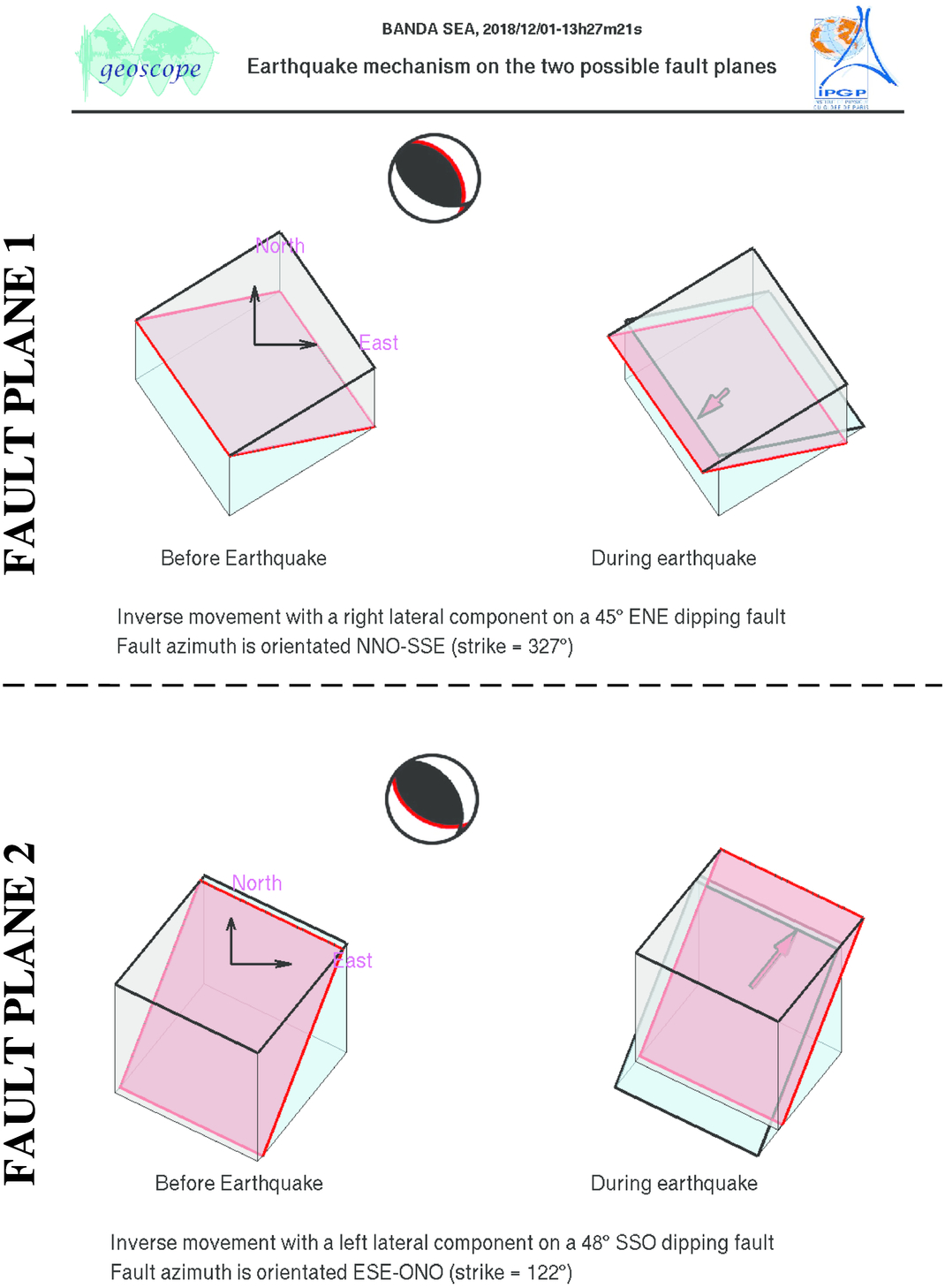
This figure illustrates how the two blocks separated by the seismic fault are displaced during the earthquake. These movements are deduced from the SCARDEC focal mechanism, on the two possible fault planes. Additional information (tectonics, near-fault measurements) is required to determine which one of these two hypotheses corresponds to the real movements during the earthquake.
Note: This part has been developed for diagnostic of Geoscope data in real-time ; data shown here have not been validated, and differences between data and synthetics should be interpreted with caution, in particular for moderate earthquakes (magnitude < 6.2) and very large earthquakes (magnitude > 7.5).
The SCARDEC solution is used here to predict the waveforms at all Geoscope stations received in real time and located at distances between 30° and 150° from the earthquake. All available location codes are used, for the BH* channels. In the range [30° - ~90°], the prediction is done on P and S(H) waves and in the range [~90° - 150°], it is done on PP and SS(H) waves. See agreement for P or PP waves (vertical components) between data and synthetics in Figure 1; see agreement for S(H) or SS(H) waves (horizontal components) between data (black) and synthetics (red) in Figure 2. Tables 1 and 2 provide quantitative estimates of these agreements.
1) STATIONS-LOCATIONCODES-COMPONENTS analyzed
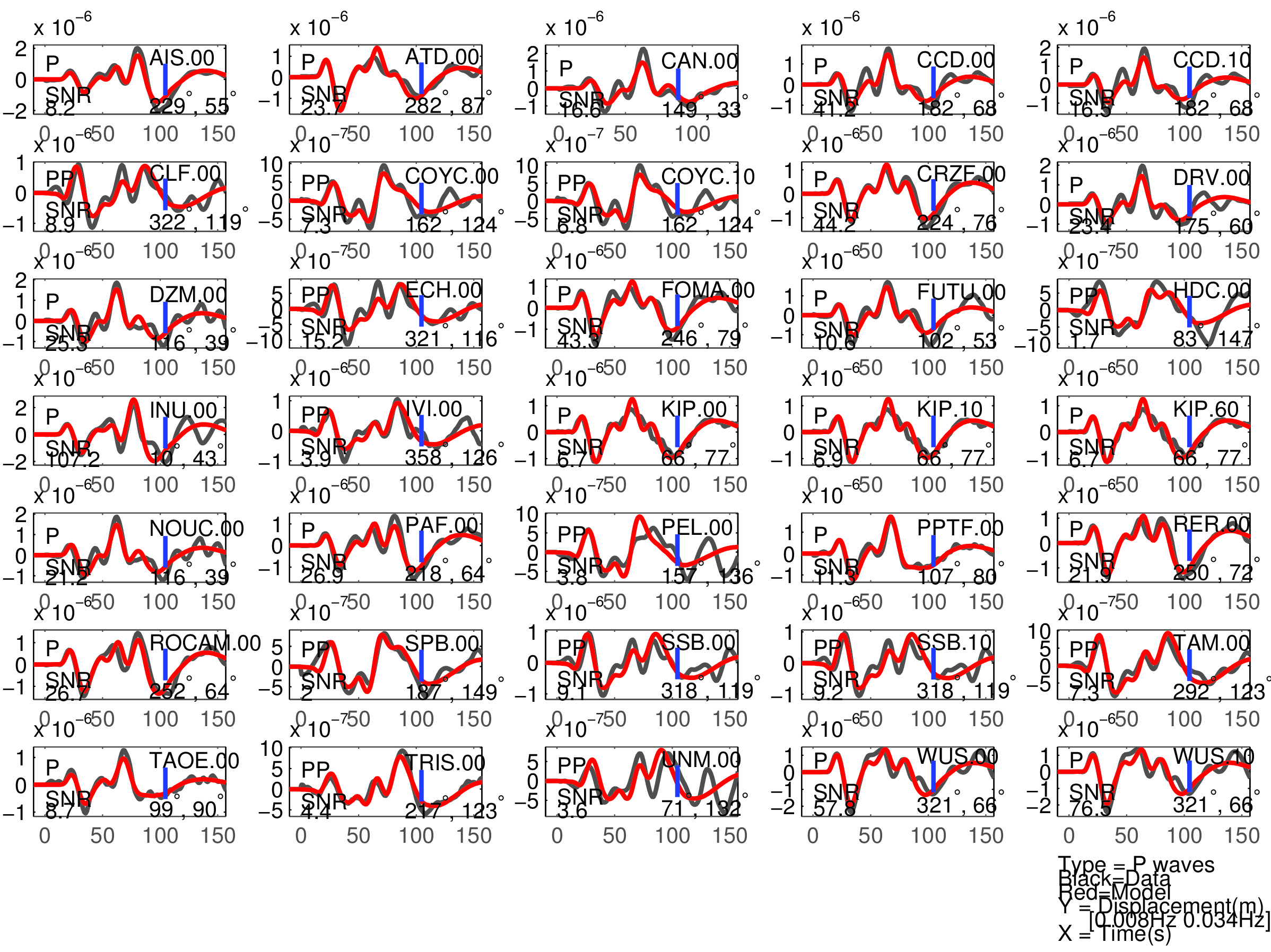
Figure 1: Agreement between data (black) and synthetics (red) for P or PP waves (the type of waves used is indicated in each subfigure). The comparison is shown with a time shift (noted 'Dt1' in Table 1), corresponding to the optimal fit ('Fit1' in Table 1) before the blue tick. Also indicated are the azimuth and distance of the station, and the signal to noise ratio (SNR). Note that the prediction done for PP waves is expected to be less accurate than the one for P waves.
Table 1: Quantitative estimates of the agreement between data and synthetics for P or PP waves :
- 'Fit1' is the variance reduction allowing an optimal time shift ('Dt1')
- 'Fit2' is the variance reduction allowing an optimal time shift ('Dt2') and an optimal amplitude normalization ('Corr_Amp'). The latter value is the factor by which data should be divided to be the closest to the synthetics.
- 'Rad' is a measure of the amplitude of the expected radiation (normalized to 1). Low values of the radiation (<0.1-0.15) are expected to reduce the significance of the comparison between data and synthetics
- 'Comment' column is filled when the data and/or the comparison between data and synthetics are not as expected.
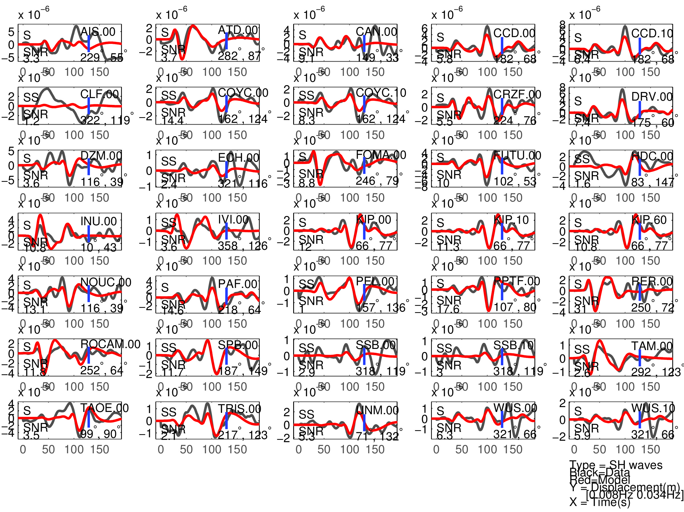
Figure 2: Same as Figure 1, but for S(H) or SS(H) waves (use of the rotated horizontal component along the transverse direction). See in Table 2 the quantitative estimates ('Dt1' and 'Fit1') corresponding to this Figure.
Table 2: Same as Table 1 for S(H) or SS(H) waves.
2) STATIONS-LOCATIONCODES-COMPONENTS not analyzed
STATIONS-LOCATIONCODES-COMPONENTS received, but TOO FAR or TOO CLOSE:
STATIONS-LOCATIONCODES-COMPONENTS not present in the 2 categories above have not been received, or on a too short time window to be analyzed
1) Overview
This page gathers information on earthquake characteristics (through the SCARDEC method, see below) and on GEOSCOPE data available for these events: The “data” tab provides access to the data seed file (20000s window starting at the earthquake origin time), provides access to the theoretical arrival times, shows earthquake waveforms for each station and channel, and presents the global Earth wave propagation through the visualization of the LHZ channel. The “mechanism” tab illustrates the geometry of the movement during the earthquake, along the two possible faults planes determined by SCARDEC analysis.
Several e-mail alerts are available, as soon as a new earthquake has been analyzed: (1) for all earthquakes, (2) for earthquakes with Mw>=6.5, and (3) for earthquakes with Mw>=7. Please contact Martin Vallée (vallee@ipgp.fr) to be added in one of these mailing lists.
2) Analysis of the earthquake source (SCARDEC method)
SCARDEC method uses the teleseismic body waves to retrieve the depth, focal mechanism, moment magnitude and source time function of earthquakes with magnitudes larger than 5.5-6. Details of the methodology are described in Vallée et al. [2011] and an application to all earthquakes with magnitude larger than 6 in the period 1992-2011 can be found in Vallée [2013]. The consolidated SCARDEC catalog, with full access to earthquake parameters and source time functions, can be found here.
In the near-real time configuration presented here, the solution is typically posted 45 minutes after earthquake occurrence. Solution includes a map summing up the SCARDEC results and a figure showing the agreement to the data. The map presents the earthquake location (together with the plate boundaries from Bird [2003] and the slab contours of SLAB 1.0 [Hayes et al., 2012]) and the main SCARDEC source parameters. Numerical values of focal mechanism parameters and seismic moment are written below the map. The data agreement figure compares the SCARDEC synthetics (red) with the FDSN data (black), in the frequency range used for focal mechanism determination. The name of GEOSCOPE stations is written in green.
See more information (about the data, the procedure, the reasons that could prevent from providing the earthquake information, the source time function determination...) in the "detailed notes"
. If using some of the SCARDEC results, please refer to:
(1) Vallée, M., J. Charléty, A.M.G. Ferreira, B. Delouis, and J. Vergoz, SCARDEC : a new technique for the rapid determination of seismic moment magnitude, focal mechanism and source time functions for large earthquakes using body wave deconvolution, Geophys. J. Int., 184, 338-358, 2011.
(2) Vallée, M., Source time function properties indicate a strain drop independent of earthquake depth and magnitude, Nature Communications, doi: 10.1038/ncomms3606, 2013.
The method is running and maintained at IPGP laboratory. Apart from IPGP, past and present support to the development of the method are/were provided by the following institutes/projects :
We are grateful to the organisms providing, managing or federating data:
is used for drawing some maps of the webpage.